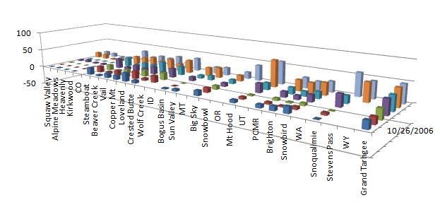
From CDC NOAA:
Week 1 (26 November -2 December 2006): GSDM Stage 1 with subtropical jets is most probable. This situation generally favors an active weather regime for the Rockies and Plains, with a southwest-northeast storm track across the central USA. An important issue is how soon deep tropical moisture transport through the Gulf of Mexico can resume after the recent surges of cool dry air. Latest observations suggest low level moistening is occurring across the Gulf of Mexico. Most models predict baroclinic development on the Plains by around the middle of next week, but with still serious phase and amplitude issues. They are "catching-up" to the changing tropical convective forcing and other processes. A thought to offer would be a slower and more amplified solution for trough development, and the models are now trending there. In any case, bitterly cold Arctic air is likely to penetrate into the Rockies and Plains by the end of this period while the Deep South warms up in advance. Depending on the details, portions of the Rockies and Plains may have severe winter weather conditions while severe local storms become a concern for the locations such as the south central states to the Ohio Valley.There is still an on-going tropical cyclone risk across the central Pacific and possibly other regions (see
the Tropical Prediction Center for links). Satellite pictures show evidence of development trying to occur west-northwest of the equatorial date line. Locations such as the Philippines may be impacted later this period. Tropical cyclone Yani is weakening in the area of the South Pacific islands; however, more development may follow. Finally, locations across the Indian Ocean may become at risk for tropical cyclone development as the MJO slowly moves east.
Week 2 (3-9 December 2006): Same as week 1, but with the usual synoptic variations in amplitude. Perhaps another episode of baroclinic development across the Rockies and Plains may occur toward the end of this period. The week 1 storm system will not be the "last western/central USA" trough in this series. In fact, the stronger and slower moving troughs may not occur until the last half of December, particularly if a transition from GSDM Stage 1-2 occurs.
Week 3 (10-16 December 2006): We may have a period during weeks 4-6 of extremely cold air covering particularly the central USA should a mature GSDM Stage 2 evolve. That may allow a snow pack to build across locations such as the Upper Mississippi Valley and Great Lakes. Given the magnitude of our warm ENSO (and other factors) I would be surprised not to see an anomalously strong combined jet ~30-35N extend from East Asia into the western USA (with split flow across North America) by ~ the middle of January 2007, which would be GSDM Stage 3. This would significantly increase the probability of high impact weather (heavy precipitation, high winds, etc.) for the USA west coast perhaps affecting California the most (other regions for hazards and weather understood).